Winter Storm Could Bring Big Snow To Sioux Falls Tri-State Area
Get your snowblower ready. The Sioux Falls Tri-State area could see the first significant snow event of the year late Thursday into Friday.
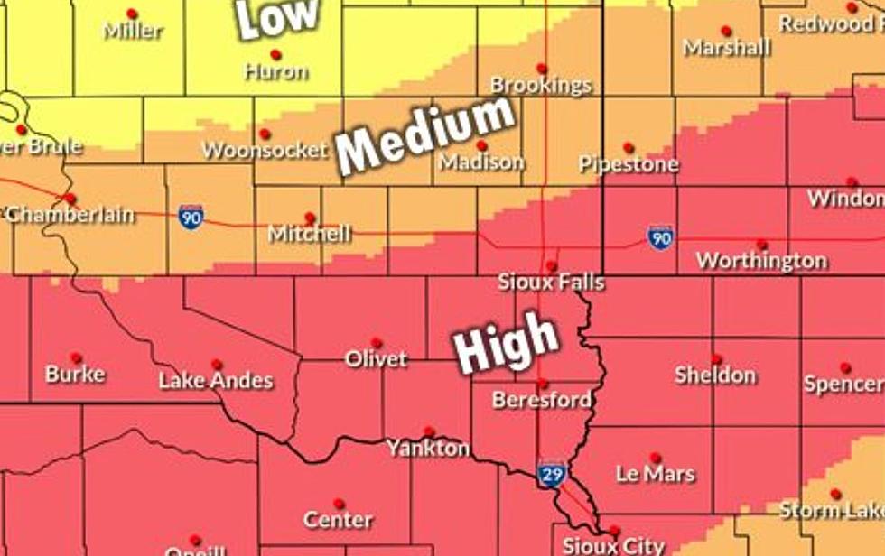
The National Weather Service is saying that the potential for the first significant snow of the season is growing, with accumulating snow likely for much of the area late Thursday night into Friday. Exact snowfall amounts remain uncertain. Continue to monitor your local forecast for updates.
Right now it looks like Sioux Falls could see 1 to 4 inches of snow on Friday with heavier amounts to the south.
MORE: Where to Find Sioux Falls Winter Weather Info - Road Reports and More

There is a Winter Storm Watch in effect from Friday morning through Friday night just south of Sioux Falls for portions of southeast South Dakota, northeast Nebraska and northwest and west-central Iowa.

Right now the following counties in the Storm Watch include Sioux, O`Brien, Clay, Plymouth, Cherokee, Buena Vista, Woodbury Dixon, Dakota, and Union.
But be sure to monitor the weather because the track of this storm could move further north and increase the snowfall amounts.
Travel could be very difficult. Patchy blowing snow could significantly reduce visibility. The hazardous conditions could impact the morning or evening commute.

Here is the latest forecast from the NWS in Sioux Falls ...
Today: Mostly sunny, with a high near 35. Light east wind becoming south southeast 10 to 15 mph in the morning.
Tonight: Mostly cloudy, with a steady temperature around 31. South southeast wind 10 to 15 mph, with gusts as high as 25 mph.
Thursday: Mostly sunny, with a high near 44. South wind 5 to 15 mph becoming northwest in the afternoon.
Thursday Night: A slight chance of snow after midnight. Increasing clouds, with a low around 25. Northwest wind around 5 mph becoming calm. The chance of precipitation is 20%.
Friday: Snow likely. Cloudy, with a high near 32. Northeast wind 5 to 15 mph. The chance of precipitation is 60%. New snow accumulation of around 3 inches.
Friday Night: Mostly cloudy, then gradually becoming mostly clear, with a low around 16. West northwest wind around 10 mph.
Saturday: Sunny, with a high near 31.
MORE FROM RESULTS TOWNSQUARE SIOUX FALLS:
- What Every South Dakotan Should Be Doing to Prepare for Winter
- South Dakota’s Strangest Winter Weather Day Ever
- 10 Must-Have Items in Your Car For Winter Survival Kit
The Coldest Temperatures EVER in Sioux Falls
Gallery Credit: Danny V
Show Off Your Christmas Display and Light Up Sioux Falls
Gallery Credit: Results-Townsquare Media Sioux Falls
More From KXRB