
UPDATE: Winter Weather Advisory Sunday Night
UPDATE Sunday, March 15, 2026, 9:15 PM
The Blizzard Warning for the Sioux Falls area has been replaced with a Winter Weather Advisory, in effect until 1:00 AM Monday.
"As the snowfall ends across the area late Sunday evening across northwest Iowa, visibility will be improving. Another improvement will be gradually decreasing winds, but that may take until early Monday morning to the east of Interstate 29 in southwest Minnesota and northwest Iowa." - NWS
URGENT - WINTER WEATHER MESSAGE
National Weather Service Sioux Falls SD
832 PM CDT Sun Mar 15 2026

NEZ013-SDZ062-066>070-160600-
/O.CAN.KFSD.BZ.W.0002.000000T0000Z-260316T0600Z/
/O.EXA.KFSD.WW.Y.0009.000000T0000Z-260316T0600Z/
Dixon-Minnehaha-Turner-Lincoln-Bon Homme-Yankton-Clay-
Including the cities of Hurley, Centerville, Chancellor, Lennox,
Marion, Parker, Springfield, Avon, Harrisburg, Tea, Allen,
Canton, Tabor, Vermillion, Wakefield, Ponca, Irene, Tyndall,
Yankton, Viborg, Sioux Falls, and Scotland
832 PM CDT Sun Mar 15 2026

...WINTER WEATHER ADVISORY IN EFFECT UNTIL 1 AM CDT MONDAY...
...BLIZZARD WARNING IS CANCELLED...

* WHAT...Widespread blowing snow. Winds gusting as high as 50 mph.

* WHERE...Portions of northeast Nebraska and southeast South Dakota.

* WHEN...Until 1 AM CDT Monday.

* IMPACTS...Widespread blowing snow, frequently reducing visibility
  below a half mile, will make travel dangerous, especially in open
  country. Gusty winds could bring down tree branches.

PRECAUTIONARY/PREPAREDNESS ACTIONS...

Use caution while traveling, especially in open areas. The latest
road conditions for the state you are calling from can be obtained
by calling 5 1 1.
UPDATE Saturday, March 14, 2026, 1:15 PM
Saturday afternoon, the National Weather Service (NWS) issued a Blizzard Warning for much of eastern South Dakota, including Sioux Falls, in effect from 4:00 AM Sunday until 1:00 AM Monday.
Wind and snow will make travel dangerous if not impossible on Sunday.
"Blizzard conditions expected. Total snow accumulations up to two inches. Winds gusting as high as 60 mph." - NWS

URGENT - WINTER WEATHER MESSAGE
National Weather Service Sioux Falls SD
111 PM CDT Sat Mar 14 2026

IAZ001-MNZ098-SDZ062-066-067-150900-
/O.UPG.KFSD.WS.A.0001.260315T0900Z-260316T1200Z/
/O.EXB.KFSD.BZ.W.0002.260315T0900Z-260316T0600Z/
Lyon-Rock-Minnehaha-Turner-Lincoln-
Including the cities of Chancellor, Harrisburg, Inwood,
Larchwood, Centerville, Parker, George, Luverne, Hurley, Tea,
Sioux Falls, Viborg, Canton, Lennox, Rock Rapids, Marion, and
Irene
111 PM CDT Sat Mar 14 2026

...BLIZZARD WARNING IN EFFECT FROM 4 AM SUNDAY TO 1 AM CDT MONDAY...

* WHAT...Blizzard conditions expected. Total snow accumulations up
  to two inches. Winds gusting as high as 60 mph.

* WHERE...In Iowa, Lyon County. In Minnesota, Rock County. In South
  Dakota, Lincoln, Minnehaha, and Turner Counties.

* WHEN...From 4 AM Sunday to 1 AM CDT Monday.

* IMPACTS...Plan on slippery road conditions. Whiteout conditions
  will make travel extremely dangerous or impossible. The hazardous
  conditions could impact the Monday morning commute. Strong winds
  could cause tree damage.

PRECAUTIONARY/PREPAREDNESS ACTIONS...

Travel should be restricted to emergencies only. If you must travel,
have a winter survival kit with you. If you get stranded, stay with
your vehicle. The latest road conditions for the state you are
calling from can be obtained by calling 5 1 1.
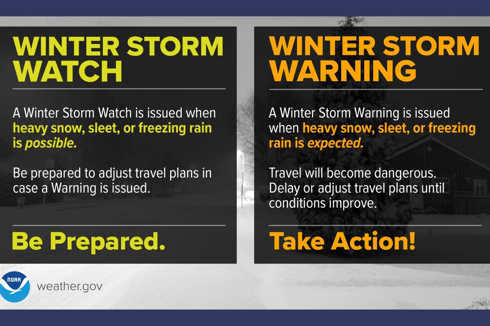
The National Weather Service (NWS) issued a Winter Storm Watch for southeast South Dakota, including Sioux Falls, as well as parts of Iowa and Minnesota. The Watch is in effect from Saturday evening (March 14) through Monday morning (March 16).
"Risks of heavy snow and blizzard conditions this weekend are growing. Areas of light snow begin early Saturday, but the greatest impacts are expected Saturday night through Sunday when snowfall totals exceeding 6 to 12 inches will be possible in portions of the region. Strong north winds develop early Sunday, and travel may become impossible due to blizzard conditions. Continue to monitor the forecast but plan now for potential travel impacts." - NWS 3/13/26
After a sunny and windy Friday, snow is expected to start overnight into Saturday. The snow could mix with rain throughout the day. The snow is expected to pick up Saturday night and continue through Sunday. As of Thursday evening, the forecast says Sioux Falls could see four to six inches of snow by Sunday evening.
URGENT - WINTER WEATHER MESSAGE
National Weather Service Sioux Falls SD
950 AM CDT Fri Mar 13 2026

IAZ001>003-012>014-021-022-032-MNZ098-SDZ062-066-067-140100-
/O.CON.KFSD.WS.A.0001.260315T0000Z-260316T1200Z/
Lyon-Osceola-Dickinson-Sioux-O`Brien-Clay-Cherokee-Buena Vista-
Ida-Rock-Minnehaha-Turner-Lincoln-
Including the cities of Viborg, Milford, Spencer, Luverne, Orange
City, Tea, Holstein, Sheldon, Ida Grove, Sibley, Larchwood,
Cherokee, George, Hurley, Chancellor, Irene, Spirit Lake,
Centerville, Hawarden, Hartley, Sioux Center, Arnolds Park,
Sanborn, Storm Lake, Rock Rapids, Inwood, Battle Creek,
Harrisburg, Sioux Falls, Canton, Parker, Hull, Lennox, Marion,
and Rock Valley
950 AM CDT Fri Mar 13 2026

...WINTER STORM WATCH REMAINS IN EFFECT FROM SATURDAY EVENING
THROUGH MONDAY MORNING...

* WHAT...Blizzard conditions possible. Total snow accumulations
  between 4 and 9 inches and ice accumulations around one tenth of
  an inch possible. Winds could gust as high as 55 mph.

* WHERE...Portions of northwest and west central Iowa, southwest
  Minnesota, and southeast South Dakota.

* WHEN...From Saturday evening through Monday morning.

* IMPACTS...Visibilities may drop below 1/2 mile due to falling
  and/or blowing snow at times. Travel could be very difficult.
  Whiteout conditions may make travel extremely dangerous or
  impossible. The hazardous conditions could impact the Monday
  morning commute. Strong winds could cause tree damage.

PRECAUTIONARY/PREPAREDNESS ACTIONS...

Prepare for possible blizzard conditions. Continue to monitor the
latest forecasts for updates on this situation.

&&
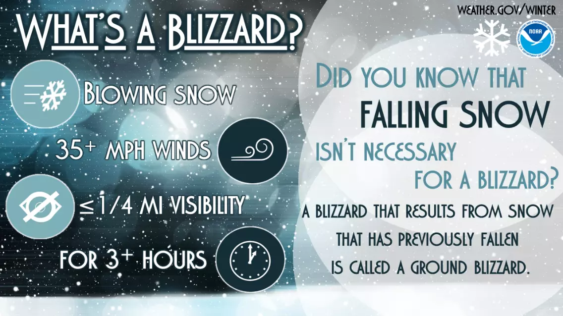
Winter Weather Tips From the National Weather Service
Gallery Credit: National Weather Service